


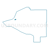
Fairview Precinct, Anchorage Municipality, Alaska
About
Outline

Summary
| Unique Area Identifier | 523242 |
| Name | Fairview Precinct |
| County | Anchorage Municipality |
| State | Alaska |
| Area (square miles) | 1.47 |
| Land Area (square miles) | 1.47 |
| Water Area (square miles) | 0.00 |
| % of Land Area | 100.00 |
| % of Water Area | 0.00 |
| Latitude of the Internal Point | 61.22085860 |
| Longtitude of the Internal Point | -149.85059140 |
Maps

Graphs
Select a template below for downloading or customizing gragh for Fairview Precinct, Anchorage Municipality, Alaska


Neighbors
Neighoring Voting District (by Name) Neighboring Voting District on the Map
- Downtown No. 1 Precinct, Anchorage Municipality, AK
- Downtown No. 2 Precinct, Anchorage Municipality, AK
- Downtown No. 4 Precinct, Anchorage Municipality, AK
- Elmendorf Precinct, Anchorage Municipality, AK
- Government Hill No. 1 Precinct, Anchorage Municipality, AK
- Government Hill No. 2 Precinct, Anchorage Municipality, AK
- Merrill Field Precinct, Anchorage Municipality, AK
- North Mountain View No. 2 Precinct, Anchorage Municipality, AK
Top 10 Neighboring County Subdivision (by Population) Neighboring County Subdivision on the Map
Top 10 Neighboring Place (by Population) Neighboring Place on the Map
Top 10 Neighboring Unified School District (by Population) Neighboring Unified School District on the Map
Top 10 Neighboring State Legislative District Lower Chamber (by Population) Neighboring State Legislative District Lower Chamber on the Map
- State House District 18, Military, AK (19,255)
- State House District 20, Mountain View-Wonder Park, AK (18,540)
- State House District 23, Downtown-Rogers Park, AK (16,958)
Top 10 Neighboring State Legislative District Upper Chamber (by Population) Neighboring State Legislative District Upper Chamber on the Map
- State Senate District J, AK (36,344)
- State Senate District L, AK (36,313)
- State Senate District I, AK (35,604)
Top 10 Neighboring 111th Congressional District (by Population) Neighboring 111th Congressional District on the Map
Top 10 Neighboring Census Tract (by Population) Neighboring Census Tract on the Map
- Census Tract 6, Anchorage Municipality, AK (7,747)
- Census Tract 4, Anchorage Municipality, AK (5,937)
- Census Tract 9.01, Anchorage Municipality, AK (4,906)
- Census Tract 10, Anchorage Municipality, AK (4,131)
- Census Tract 5, Anchorage Municipality, AK (1,988)